Underwater navigation, communications and surveillance for divers
Navigate safely underwater
UWIS is an underwater navigation, communications and surveillance system that utilises the trilateration principle.
With UWIS’s help the divers’ underwater location can be determined with just a few meters accuracy. It also enables communication between the dive participants and the surface via pre-set messages.
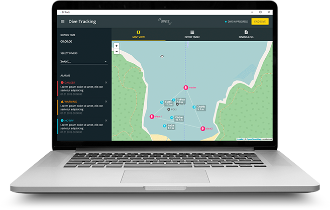
Diving information is transmitted to the surface through a buoy, where the progress of the dive can be monitored in near real time via UWIS Tracker software. Specified location data and messages are transmitted to all divers when the underwater tablet (Alltab) with navigation application is used.
The system is able to track up to 100 divers simultaneously over an area of 1000 meters across an in depth of 150 metres.
UWIS – Underwater Information Systems
Locate, navigate, communicate and collect data
UWIS system consists of three buoys and a diver unit that is attached on the air tank or above the ROV. The system communicates underwater via ultrasound.
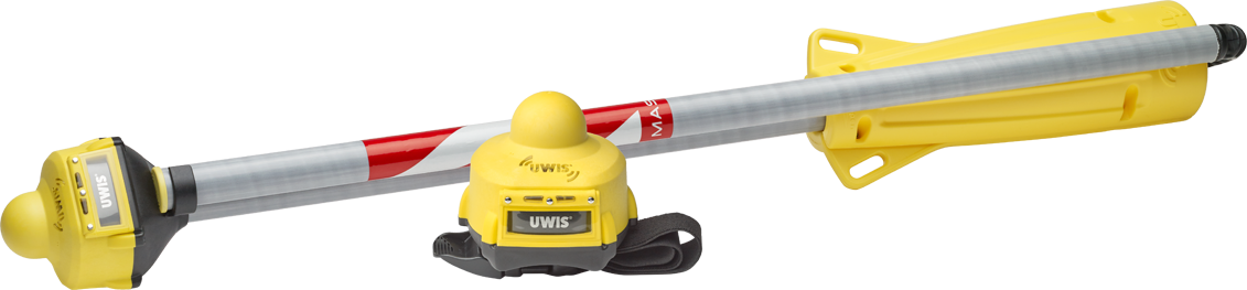
The diver unit is attached on the air tank and it communicates with the display wirelessly via Bluetooth, Wi-Fi or inductive data transfer. The communications between a diver unit and the master buoy are carried out via ultrasound.
Dimensions: 105 x 115 x 94 mm
The buoys are equipped with GPS sensors and they are connected via Wi-Fi. The divers’ location is tracked with ultrasound using trilateration principle.
Dimensions: Height 1,9 m deployed, 1,0 m stored
The UWIS Tracker application is compatible with Windows operating system. You also need WLAN connectivity.
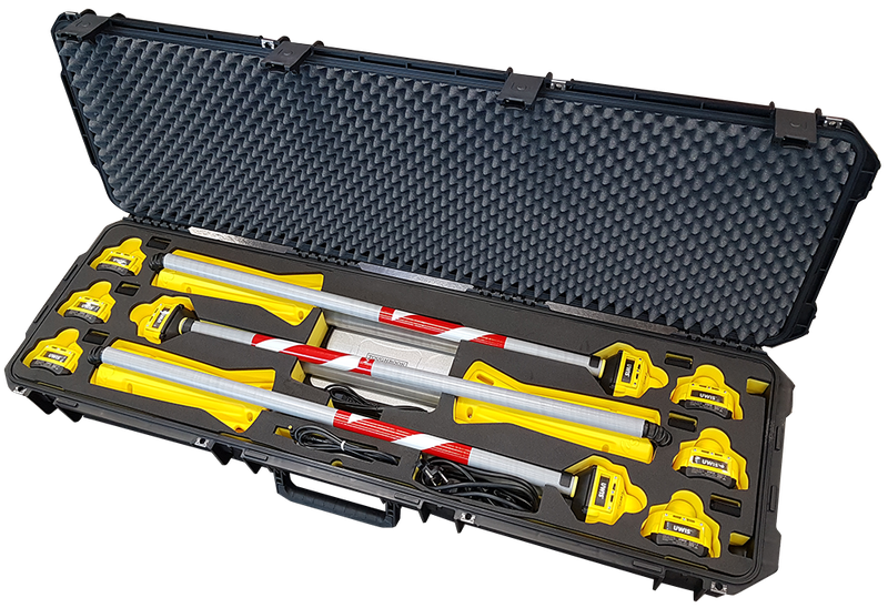
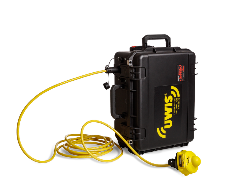
UWIS PRO Case is a ready-to-go set for tracking your dive group
Dive anywhere with UWIS' ready-to-use set for professional divers.
The set contains everything needed for tracking a dive group.
The military standard waterproof SKB hard case contains six diver units,chargers, three buoys
and a rugged Panasonic Toughbook G2 laptop (optional).
The PRO Case can be used out of the box with little installation needed. The UWIS Tracker software
is preloaded on the laptop and its installation link is shared with the System's owners.
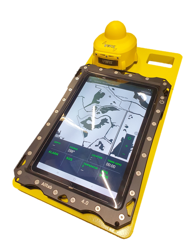
Alltab - underwater tablet with installed navigation app and mounting
Alltab is an underwater tablet featuring a patented touchscreen that can be used down to depths of 150 meters.
Alltab is the product manufactured by Valtamer Oy and is sold by UWIS, bundled with a navigation application and mounting pad that leverages the UWIS System. When installed with the UWIS Diver Unit, this setup is nearly neutrally boyant in water.
The navigation application supports, among other things, the receiving of your own and diving partners' location data, receiving and sending predifined messages, and saving new location markers.It allows for the download of free maps in the backround or the addition of one's own located image.
UWIS Cable Buoy - an alternative buoy solution for operations from vessels
The UWIS Cable Buoy is an alternative buoy solution that is better suited for operations on larger vessels.
In UWIS Cable Buoys, the underwater part is deployed below the keel of the vessel while ensuring that GNSS and Wi-Fi communication remain within a better reception area at the vessel's deck level. There are two versions available, depending on the desired accuracy level in positioning.
UWIS system functionalities
Underwater location data
UWIS tracks divers’ absolute and relative location underwater with a couple of metres accuracy. The location is transmitted to the diver itself, surface personnel and other divers via the master buoy.
Direction to the waypoint
UWIS tells the direction and distance of a dive buddy or planned waypoint. The browser-based application can track up to 100 divers simultaneously and records all dive data to be analysed or shared later.
Navigation with waypoints
UWIS enables planning of a dive by using pre-set waypoints and POIs (point of interest) to mark for example dive locations and ascension points. Using waypoints, the divers can proceed along pre-planned route underwater.
Setting waypoints
The system allows up to 100 pre-set POIs, which can be also be re-located form the surface during the dive. The diver’s display can be for example a cellular, an underwater tablet or any other supported display unit.
Communication
UWIS revolutionises communication between divers and the surface. With it the group can communicate to each other and surface using up to 100 pre-set messages or alarms.
Alarms
UWIS has multiple alarms that can be set for example for depth, distance to dive buddy or dive master or ascension point. The alarms are automatic and they can be used according to the needs and wishes of the divers.
Monitoring the dive
UWIS allows monitoring of the dive from the surface. The application shows location of the divers and waypoints on a map and relays all messages and alarms.
Directing a group
UWIS allows the surface personnel to contact single divers or the whole group simultaneously. Dive leader can for example order them to surface, re-direct them to a new waypoint or alter the ascension point.
UWIS is versatile
UWIS is already more comprehensive than any other alternative system. The UWIS company updates the software, buoys and diver units constantly and new applications and devices are developed for the system in co-operation with world’s leading dive equipment manufacturers and diving organisations.
UWIS system features
Tracking, number of divers simultaneously
100
Pre-set waypoints or POIs
100
Dive data recording
Location in coordinates, time, depth, temperature etc.
Location accuracy
Absolute: ±2,5 m, relative: ±0,5 m
Depth accuracy
±0,1 m
Maximum depth
150 m
Diameter of monitored area
1000 m
Max distance of the computer from the master buoy
200 m
Battery life, minimum
14 h (li-ion)
Wireless firmware update
Wireless charging 4/7 h
24/7 product support